Spatio-temporal analysis of dzud hazard in Mongolia
![]()
General Information
This section aims to describe the climate datasets available within the Spatio-temporal Analysis of Dzud Hazard workspace for Mongolia available in mCube and developed for the Indonesia Resident Mission of the Asian Development Bank.
The aim of this dataset is to provide multiple climate indices with potential significance to dzud precursor conditions in dzud-affected areas in Mongolia. These products support the process understanding of dzud genesis for iron dzud, allow identifying dzud prone areas and may serve as a basis for holistic approaches building upon a robust data base on dzud drivers.
This climate dataset is developed by the national meteorological and geophysical service of Austria, the Central Institution for Meteorology and Geodynamics (ZAMG), in the framework of the ESA’s GDA AID Disaster Resilience project for the Use Case 7 Spatio-temporal analysis of dzud hazard in Mongolia.
![]()
Context
Dzud events are severe meteorological events that have affected Mongolia throughout history. A Dzud is a combination of deep cold, strong winds, heavy snow, and ice which leads to large-scale deaths of livestock due to starvation, causing huge economic damage for pastoral nomadic communities in Mongolia1. The harshest dzud event occurred in the 2009-2010 winter season killing 10.3 million livestock2.
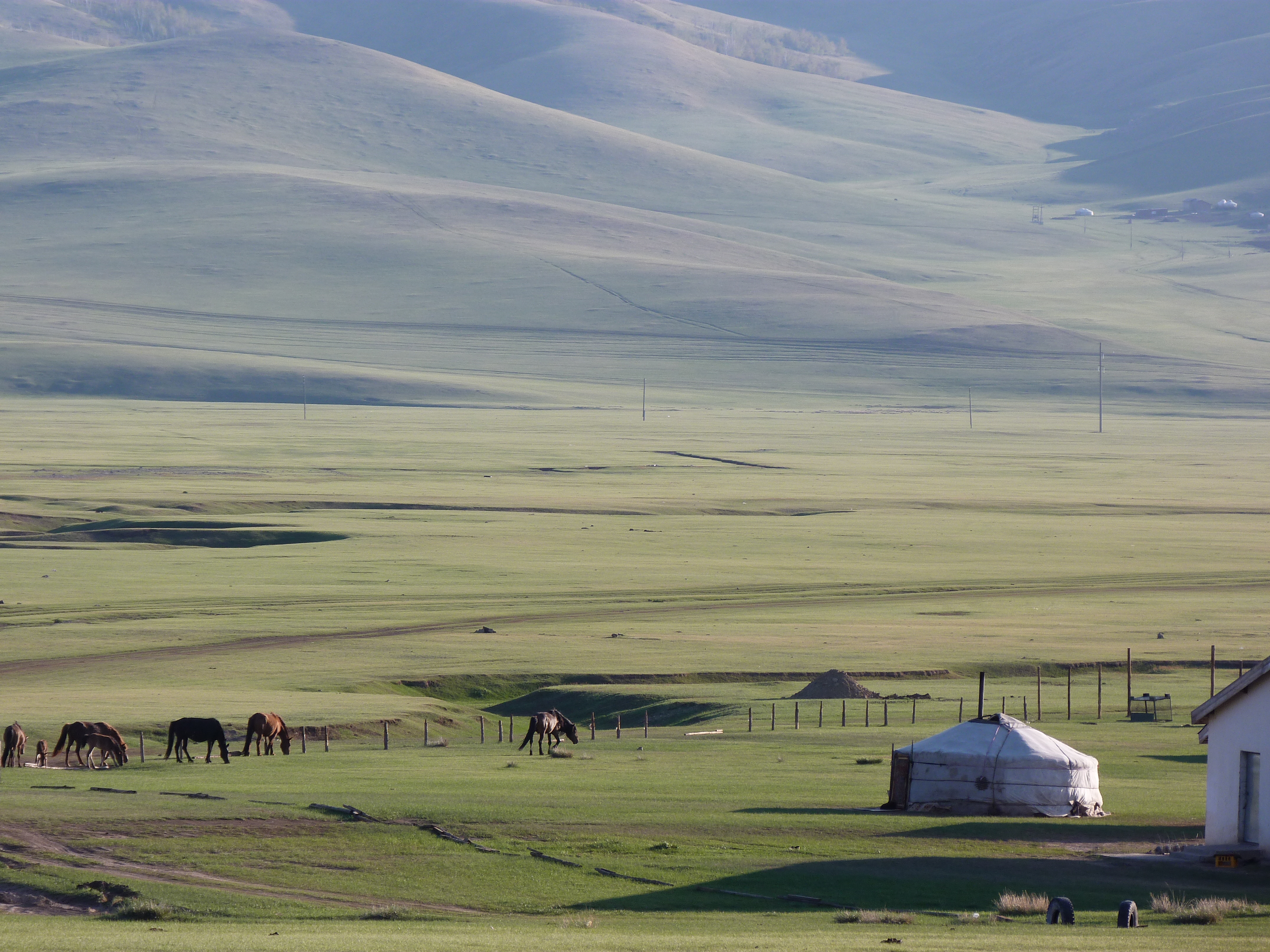
Figure 1: Mongolia: Pastoral communities continue to struggle with the effects of Dzud. Photo credit: EU Civil Protection and Humanitarian Aid. 3.
The GDA AID DR Use Case 74 focuses on: “the spatial and temporal characteristics of the main meteorological hazard components of dzud, including locations and time points of severe meteorological conditions, with the aim to identify patterns of dzud genesis”.
To foster a better understanding of dzud events, gaining knowledge about the main drivers is of core importance. Consequently, comprehensive data about dzud precursor conditions are of particular interest. Spatially resolved time series of meteorological drivers (e.g., snow, temperature, ice, water availability, etc.) can serve as a basis for establishing thresholds to identify meteorological events with relevance to different dzud types.
Spatio- temporal analysis of meteorological dzud hazards advances our understanding of dzud genesis. Enhanced knowledge regarding important meteorological hazards that are dzud drivers is a prerequisite for future studies aiming for impact/risk assessment.
Dataset description
Multiple types of dzud5 exist, which are characterised by different precursor conditions and different drivers leading up to dzud occurrence. This climate dataset focuses only on one of them, the iron dzud (Tumur), which consists of the loss of access by cattle to grass due to ice cover. This type of dzud predominantly occurs after snowmelt and re-freezing due to rapid changes in temperature6.
Climate indices related to iron dzud
Thus, this dataset consists of multiple iron-dzud related climate indices over an extended period of time. It includes 15 climate indices derived from 4 different databases: ERA5-Land 2m temperature (ERA5-Land), Snow (SNOWGRID CL), Frozen surface state (FSS), and Land Surface Temperature (LST).
An example is the Snow Cover Duration (SCD) index, which is defined as the seasonal count of days with a snow height > 10cm. The below Figure 1 shows a result from the SCD index for 2021 over the Khuvsgul aimag location in Mongolia.
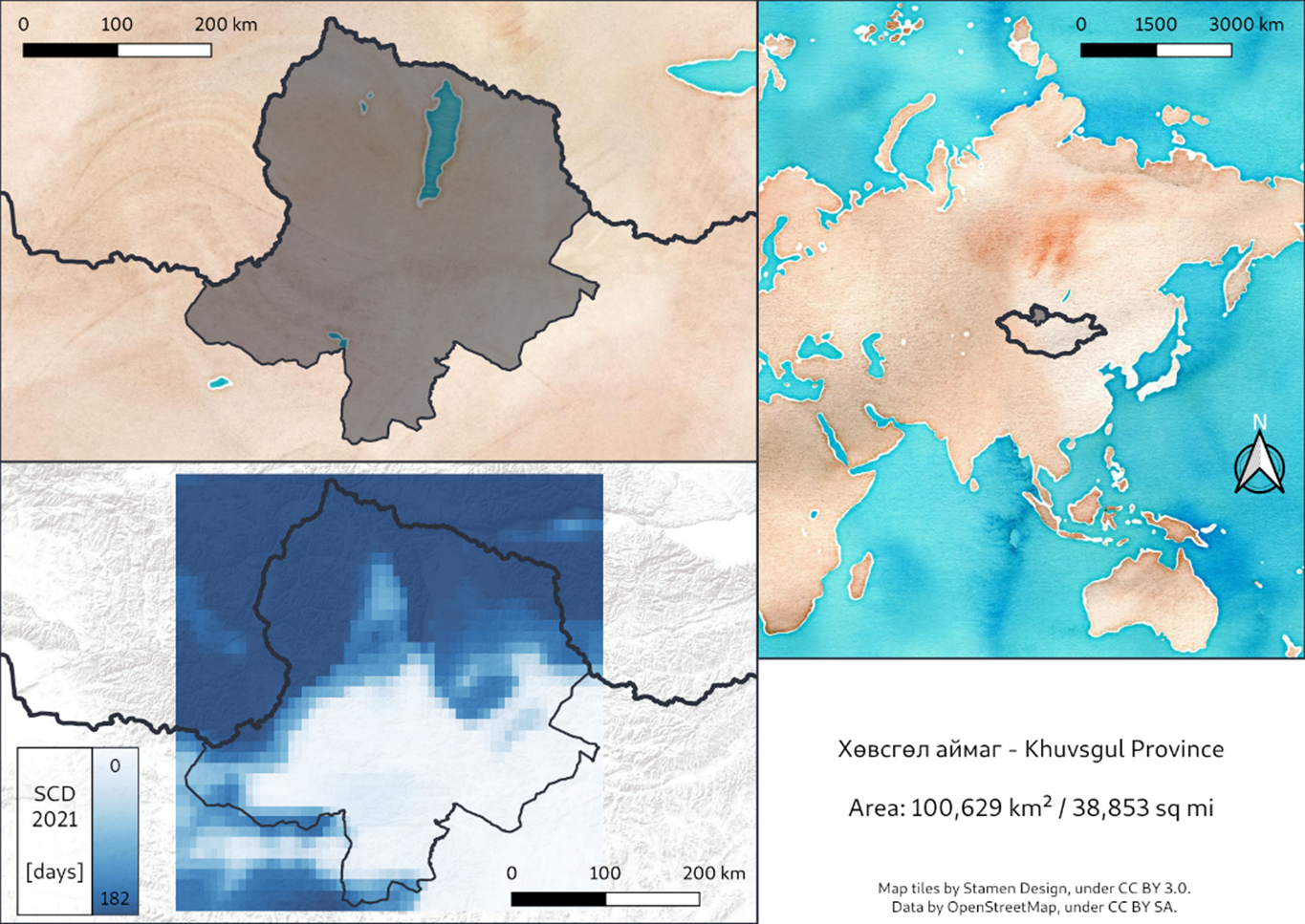
Figure 2: Bottom left: Snow cover duration (SCD) index based on SNOWGRID-CL driven with ERA5-Land for winter season 2021 (2020-12-01 to 2021-05-31). The black outline shows the boundary of Khuvsgul aimag. Top maps show the location of Khuvsgul aimag within Mongolia.
When a different data basis is employed to extract the same index, they are offered as distinct products. In total the dataset includes 22 index products.
Note
Temperature-based indices (TNn, TNx, TXn, TXx) are calculated for two datasets, EO-based land surface temperature (LST) as well as ERA5-Land reanalysis 2m temperature.
Note
Consecutive Frost Days (CFD), Number of CFD periods (CFDN5), and Number of Frost Days (FD) indices are calculated for two datasets, Frozen Surface State (FSS) as well as ERA5-Land reanalysis 2m temperature.
Products derived from ERA5-Land, SNOWGRID CL, FSS and LST are listed in Table 1, 2, 3, and 4 respectively.
| # | Index | Index full name | Index description |
|---|---|---|---|
| 01 | CFD | Consecutive frost days index | Seasonal largest number of consecutive days where TN < 0 °C. |
| 02 | CFDN5 | Number of CFD periods | Number of CFD periods with more than 5 days. |
| 03 | CWDI | Cold wave duration index | Seasonal count of days with at least 6 consecutive days when TN < 10th percentile. |
| 04 | CWN | Number of cold-waves | Seasonal count of cold-waves with at least 6 days duration |
| 05 | FD | Number of frost days | Seasonal count of days when TN (daily minimum temperature) < 0°C. |
| 06 | FTD | Number of freeze-thaw days | Seasonal count of days when TN (daily minimum temperature) < 0 °C and TX (daily maximum temperature) > 0 °C. |
| 07 | ID | Number of icing days | Seasonal count of days when TX (daily maximum temperature) < 0 °C. |
| 08 | TNn | Seasonal minimum of temperature minima | Minimum value of daily minimum temperature. |
| 09 | TNx | Seasonal maximum of temperature minima | Maximum value of daily minimum temperature. |
| 10 | TXn | Seasonal minimum of temperature maxima | Minimum value of daily maximum temperature |
| 11 | TXx | Seasonal maximum of temperature maxima | Maximum value of daily maximum temperature |
Table 1 - List of climate indices derived with ERA5-Land 2m temperature (ERA5-Land) as data basis.
| # | Index | Index full name | Index description |
|---|---|---|---|
| 12 | meanHS | Mean winter/spring snow height | Seasonal mean of snow height |
| 13 | SCD or SCD10 | Snow cover duration | Seasonal count of days with a snow height > 10cm |
| 14 | SCD1 | Snow cover duration | Seasonal count of days with a snow height > 1cm |
| 15 | SCD21 | Snow cover duration | Seasonal count of days with a snow height > 21cm |
Table 2 - List of climate indices derived with Snow (SNOWGRID CL) as data basis.
| # | Index | Index full name | Index description |
|---|---|---|---|
| 16 | CFD | Consecutive frost days index | Seasonal largest number of consecutive days where TN < 0 °C. |
| 17 | CFDN5 | Number of CFD periods | Number of CFD periods with more than 5 days. |
| 18 | FD | Number of frost days | Seasonal count of days when TN (daily minimum temperature) < 0°C. |
Table 3 - List of climate indices derived with Frozen surface state (FSS) as data basis.
| # | Index | Index full name | Index description |
|---|---|---|---|
| 19 | TNn | Seasonal minimum of temperature minima | Minimum value of daily minimum temperature. |
| 20 | TNx | Seasonal maximum of temperature minima | Maximum value of daily minimum temperature. |
| 21 | TXn | Seasonal minimum of temperature maxima | Minimum value of daily maximum temperature |
| 22 | TXx | Seasonal maximum of temperature maxima | Maximum value of daily maximum temperature |
Table 4 - List of climate indices derived with Land Surface Temperature (LST) as data basis.
Temporal coverage
Temporal coverage for climate indices is of multiple years with annual frequency (seasonal). For each index this depends on the data coverage of source data basis (see Table 5).
| Data basis of climate indexes | Temporal coverage |
|---|---|
| ERA5-Land | from 1951 to 2021 |
| SNOWGRID CL | from 1950 to 2022 |
| Frozen surface state (FSS) | from 1993 to 2020 |
| Land Surface Temperature (LST) | from 1996 to 2020 |
Table 5 - Temporal coverage for climate indices as function of source databases.
Indices are computed for an annual winter season spanning from December of the preceding year to May of the respective year.
As an example for ERA5-Land derived index products, a total of 73 seasonal estimations of each of the 10 indexes are offered in this dataset. Each of them is accessible in mCube as a single Dataset.
Spatial cover and resolution
Indexes are offered only over two portions of Mongolia covering the Khovsgol and Zavkhan provinces.
Climate index products are offered as raster at different spatial resolutions from 0.01° (~ 1 km) to 0.25° (~ 25 km). Also, spatial resolution is function of the source data basis (see Table 6).
| Data basis of climate indexes | Spatial resolution |
|---|---|
| ERA5-Land | 0.1 deg (~ 10 km) |
| SNOWGRID CL | 0.1 deg (~ 10 km) |
| Frozen surface state (FSS) | 0.25 deg (~ 25 km) |
| Land Surface Temperature (LST) | 0.01 deg (~ 1 km) |
Table 6 - Spatial resolution for climate indices as function of source databases.
Filename convention
Each index product is accessible in mCube as a single file and is following a filename convention. As an example for the SCD index derived from the SNOWGRID CL database the filename convention is the following:
GDA-AID-DR_UC7-ADBMON_Product_{data_basis}-{index}-{version}_IronDzud-{aoi}-{year}.tif
where:
-
{data_basis}indicate the data basis employed to derive the cliamte index (e.g.SNOWGRID-CL), -
{index}acronym for the climate index (e.g.SCD), -
{version}product version (e.g.V01), -
{aoi}name of the area of interest (e.g.Khuvsgul), -
{year}stands for the year of the respective winter season (e.g.1950).
Example:
GDA-AID-DR_UC7-ADBMON_Product_SNOWGRID-CL-SCD-V01_IronDzud-Khuvsgul-1950.tif
Product specification tables
All the 22 climate index products listed in Tables 1, 2, 3 and 4 are catalogued in mCube as single-band assets in a dedicated STAC item.
Product specifications for each product can be found in below tables:
Product Specifications of climate indices from ERA5-Land
| Attribute | Value / description |
|---|---|
| Long Name | Consecutive Frost Days (CFD) index from ERA5-Land |
| Short name | CFD |
| Description | Seasonal largest number of consecutive days where TN < 0 °C. |
| Temporal coverage | from 1951 to 2021 |
| Filename convention | GDA-AID-DR_UC7-ADBMON_Product_ERA5-Land-CFD-V01_IronDzud-Khuvsgul-YYYY |
| where YYYY stands for the year (e.g. 1951). | |
| Data Type | Float32 |
| Band | Single |
| Format | COG |
| Projection | EPSG:4326 - WGS84 Geographic |
| Resolution | 0.1 deg |
| No Data Value | nan |
| Attribute | Value / description |
|---|---|
| Long Name | Number of CFD periods (CFDN5) index from ERA5-Land |
| Short name | CFDN5 |
| Description | Number of CFD periods with more than 5 days. |
| Temporal coverage | from 1951 to 2021 |
| Filename convention | GDA-AID-DR_UC7-ADBMON_Product_ERA5-Land-CFDN5-V01_IronDzud-Khuvsgul-YYYY |
| where YYYY stands for the year (e.g. 1951). | |
| Data Type | Float32 |
| Band | Single |
| Format | COG |
| Projection | EPSG:4326 - WGS84 Geographic |
| Resolution | 0.1 deg |
| No Data Value | nan |
| Attribute | Value / description |
|---|---|
| Long Name | Cold wave duration index (CWDI) index from ERA5-Land |
| Short name | CWDI |
| Description | Seasonal count of days with at least 6 consecutive days when TN < 10th percentile. |
| Temporal coverage | from 1951 to 2021 |
| Filename convention | GDA-AID-DR_UC7-ADBMON_Product_ERA5-Land-CWDI-V01_IronDzud-Khuvsgul-YYYY |
| where YYYY stands for the year (e.g. 1951). | |
| Data Type | Float32 |
| Band | Single |
| Format | COG |
| Projection | EPSG:4326 - WGS84 Geographic |
| Resolution | 0.1 deg |
| No Data Value | nan |
| Attribute | Value / description |
|---|---|
| Long Name | Number of cold-waves (CWN) index from ERA5-Land |
| Short name | CWN |
| Description | Seasonal count of cold-waves with at least 6 days duration. |
| Temporal coverage | from 1951 to 2021 |
| Filename convention | GDA-AID-DR_UC7-ADBMON_Product_ERA5-Land-CWN-V01_IronDzud-Khuvsgul-YYYY |
| where YYYY stands for the year (e.g. 1951). | |
| Data Type | Float32 |
| Band | Single |
| Format | COG |
| Projection | EPSG:4326 - WGS84 Geographic |
| Resolution | 0.1 deg |
| No Data Value | nan |
| Attribute | Value / description |
|---|---|
| Long Name | Number of frost days (FD) index from ERA5-Land |
| Short name | FD |
| Description | Seasonal count of days when TN (daily minimum temperature) < 0°C. |
| Temporal coverage | from 1951 to 2021 |
| Filename convention | GDA-AID-DR_UC7-ADBMON_Product_ERA5-Land-FD-V01_IronDzud-Khuvsgul-YYYY |
| where YYYY stands for the year (e.g. 1951). | |
| Data Type | Float32 |
| Band | Single |
| Format | COG |
| Projection | EPSG:4326 - WGS84 Geographic |
| Resolution | 0.1 deg |
| No Data Value | nan |
| Attribute | Value / description |
|---|---|
| Long Name | Number of freeze-thaw days (FTD) index from ERA5-Land |
| Short name | FTD |
| Description | Seasonal count of days when TN (daily minimum temperature) < 0 °C and TX (daily maximum temperature) > 0 °C. |
| Temporal coverage | from 1951 to 2021 |
| Filename convention | GDA-AID-DR_UC7-ADBMON_Product_ERA5-Land-FTD-V01_IronDzud-Khuvsgul-YYYY |
| where YYYY stands for the year (e.g. 1951). | |
| Data Type | Float64 |
| Band | Single |
| Format | COG |
| Projection | EPSG:4326 - WGS84 Geographic |
| Resolution | 0.1 deg |
| No Data Value | N.A. |
| Attribute | Value / description |
|---|---|
| Long Name | Number of icing days (ID) index from ERA5-Land |
| Short name | ID |
| Description | Seasonal count of days when TX (daily maximum temperature) < 0 °C. |
| Temporal coverage | from 1951 to 2021 |
| Filename convention | GDA-AID-DR_UC7-ADBMON_Product_ERA5-Land-ID-V01_IronDzud-Khuvsgul-YYYY |
| where YYYY stands for the year (e.g. 1951). | |
| Data Type | Float32 |
| Band | Single |
| Format | COG |
| Projection | EPSG:4326 - WGS84 Geographic |
| Resolution | 0.1 deg |
| No Data Value | nan |
| Attribute | Value / description |
|---|---|
| Long Name | Seasonal minimum of temperature minima (TNn) index from ERA5-Land |
| Short name | TNn |
| Description | Minimum value of daily minimum temperature. |
| Temporal coverage | from 1951 to 2021 |
| Filename convention | GDA-AID-DR_UC7-ADBMON_Product_ERA5-Land-TNn-V01_IronDzud-Khuvsgul-YYYY |
| where YYYY stands for the year (e.g. 1951). | |
| Data Type | Float32 |
| Band | Single |
| Format | COG |
| Projection | EPSG:4326 - WGS84 Geographic |
| Resolution | 0.1 deg |
| No Data Value | nan |
| Attribute | Value / description |
|---|---|
| Long Name | Seasonal maximum of temperature minima (TNx) index from ERA5-Land |
| Short name | TNx |
| Description | Maximum value of daily minimum temperature. |
| Temporal coverage | from 1951 to 2021 |
| Filename convention | GDA-AID-DR_UC7-ADBMON_Product_ERA5-Land-TNx-V01_IronDzud-Khuvsgul-YYYY |
| where YYYY stands for the year (e.g. 1951). | |
| Data Type | Float32 |
| Band | Single |
| Format | COG |
| Projection | EPSG:4326 - WGS84 Geographic |
| Resolution | 0.1 deg |
| No Data Value | nan |
| Attribute | Value / description |
|---|---|
| Long Name | Seasonal minimum of temperature maxima (TXn) index from ERA5-Land |
| Short name | TXn |
| Description | Minimum value of daily maximum temperature. |
| Temporal coverage | from 1951 to 2021 |
| Filename convention | GDA-AID-DR_UC7-ADBMON_Product_ERA5-Land-TXn-V01_IronDzud-Khuvsgul-YYYY |
| where YYYY stands for the year (e.g. 1951). | |
| Data Type | Float32 |
| Band | Single |
| Format | COG |
| Projection | EPSG:4326 - WGS84 Geographic |
| Resolution | 0.1 deg |
| No Data Value | nan |
| Attribute | Value / description |
|---|---|
| Long Name | Seasonal maximum of temperature maxima (TXx) index from ERA5-Land |
| Short name | TXx |
| Description | Maximum value of daily maximum temperature. |
| Temporal coverage | from 1951 to 2021 |
| Filename convention | GDA-AID-DR_UC7-ADBMON_Product_ERA5-Land-TXx-V01_IronDzud-Khuvsgul-YYYY |
| where YYYY stands for the year (e.g. 1951). | |
| Data Type | Float32 |
| Band | Single |
| Format | COG |
| Projection | EPSG:4326 - WGS84 Geographic |
| Resolution | 0.1 deg |
| No Data Value | nan |
Product Specifications of climate indices from SNOWGRID CL
| Attribute | Value / description |
|---|---|
| Long Name | Mean winter/spring snow height (meanHS) index from SNOWGRID CL |
| Short name | meanHS |
| Description | Seasonal mean of snow height. |
| Temporal coverage | from 1950 to 2022 |
| Filename convention | GDA-AID-DR_UC7-ADBMON_Product_SNOWGRID-CL-meanHS-V01_IronDzud-Khuvsgul-YYYY |
| where YYYY stands for the year (e.g. 1950). | |
| Data Type | Float32 |
| Band | Single |
| Format | COG |
| Projection | EPSG:4326 - WGS84 Geographic |
| Unit | meters |
| Resolution | 0.1 deg |
| No Data Value | N.A. |
| Attribute | Value / description |
|---|---|
| Long Name | Maximum winter/spring snow height (maxHS) index from SNOWGRID CL |
| Short name | maxHS |
| Description | Seasonal maximum of snow height. |
| Temporal coverage | from 1950 to 2022 |
| Filename convention | GDA-AID-DR_UC7-ADBMON_Product_SNOWGRID-CL-maxHS-V01_IronDzud-Khuvsgul-YYYY |
| where YYYY stands for the year (e.g. 1950). | |
| Data Type | Float32 |
| Band | Single |
| Format | COG |
| Projection | EPSG:4326 - WGS84 Geographic |
| Unit | meters |
| Resolution | 0.1 deg |
| No Data Value | N.A. |
| Attribute | Value / description |
|---|---|
| Long Name | Snow cover duration (SCD) index from SNOWGRID CL |
| Short name | SCD or SCD10 |
| Description | Seasonal count of days with a snow height > 10cm. |
| Temporal coverage | from 1950 to 2022 |
| Filename convention | GDA-AID-DR_UC7-ADBMON_Product_SNOWGRID-CL-SCD-V01_IronDzud-Khuvsgul-YYYY |
| where YYYY stands for the year (e.g. 1950). | |
| Data Type | Float32 |
| Band | Single |
| Format | COG |
| Projection | EPSG:4326 - WGS84 Geographic |
| Unit | days |
| Resolution | 0.1 deg |
| No Data Value | nan |
| Attribute | Value / description |
|---|---|
| Long Name | Snow cover duration (SCD1) index from SNOWGRID CL |
| Short name | SCD1 |
| Description | Seasonal count of days with a snow height > 1cm. |
| Temporal coverage | from 1950 to 2022 |
| Filename convention | GDA-AID-DR_UC7-ADBMON_Product_SNOWGRID-CL-SCD1-V01_IronDzud-Khuvsgul-YYYY |
| where YYYY stands for the year (e.g. 1950). | |
| Data Type | Float32 |
| Band | Single |
| Format | COG |
| Projection | EPSG:4326 - WGS84 Geographic |
| Unit | days |
| Resolution | 0.1 deg |
| No Data Value | nan |
| Attribute | Value / description |
|---|---|
| Long Name | Snow cover duration (SCD21) index from SNOWGRID CL |
| Short name | SCD21 |
| Description | Seasonal count of days with a snow height > 21cm. |
| Temporal coverage | from 1950 to 2022 |
| Filename convention | GDA-AID-DR_UC7-ADBMON_Product_SNOWGRID-CL-SCD21-V01_IronDzud-Khuvsgul-YYYY |
| where YYYY stands for the year (e.g. 1950). | |
| Data Type | Float32 |
| Band | Single |
| Format | COG |
| Projection | EPSG:4326 - WGS84 Geographic |
| Unit | days |
| Resolution | 0.1 deg |
| No Data Value | nan |
Product Specifications of climate indices from Frozen Surface State (FSS)
| Attribute | Value / description |
|---|---|
| Long Name | Consecutive Frost Days (CFD) index from Frozen Surface State (FSS) |
| Short name | CFD |
| Description | Seasonal largest number of consecutive days where TN < 0 °C. |
| Temporal coverage | from 1993 to 2020 |
| Filename convention | GDA-AID-DR_UC7-ADBMON_Product_FSS-CFD-V01_IronDzud-Khuvsgul-YYYY |
| where YYYY stands for the year (e.g. 1993). | |
| Data Type | Int16 |
| Band | Single |
| Format | COG |
| Projection | EPSG:4326 - WGS84 Geographic |
| Resolution | 0.25 deg |
| No Data Value | -32768 |
| Attribute | Value / description |
|---|---|
| Long Name | Number of CFD periods (CFDN5) index from Frozen Surface State (FSS) |
| Short name | CFDN5 |
| Description | Number of CFD periods with more than 5 days. |
| Temporal coverage | from 1993 to 2020 |
| Filename convention | GDA-AID-DR_UC7-ADBMON_Product_FSS-CFDN5-V01_IronDzud-Khuvsgul-YYYY |
| where YYYY stands for the year (e.g. 1993). | |
| Data Type | Int16 |
| Band | Single |
| Format | COG |
| Projection | EPSG:4326 - WGS84 Geographic |
| Resolution | 0.25 deg |
| No Data Value | -32768 |
| Attribute | Value / description |
|---|---|
| Long Name | Number of frost days (FD) index from Frozen Surface State (FSS) |
| Short name | FD |
| Description | Seasonal count of days when TN (daily minimum temperature) < 0°C. |
| Temporal coverage | from 1993 to 2020 |
| Filename convention | GDA-AID-DR_UC7-ADBMON_Product_FSS-FD-V01_IronDzud-Khuvsgul-YYYY |
| where YYYY stands for the year (e.g. 1951). | |
| Data Type | Int16 |
| Band | Single |
| Format | COG |
| Projection | EPSG:4326 - WGS84 Geographic |
| Resolution | 0.25 deg |
| No Data Value | -32768 |
Product Specifications of climate indices from Land Surface Temperature (LST)
| Attribute | Value / description |
|---|---|
| Long Name | Seasonal minimum of temperature minima (TNn) index from Land Surface Temperature (LST) |
| Short name | TNn |
| Description | Minimum value of daily minimum temperature. |
| Temporal coverage | from 1996 to 2020 |
| Filename convention | GDA-AID-DR_UC7-ADBMON_Product_ERA5-Land-TNn-V01_IronDzud-Khuvsgul-YYYY |
| where YYYY stands for the year (e.g. 1996). | |
| Data Type | Float32 |
| Band | Single |
| Format | COG |
| Projection | EPSG:4326 - WGS84 Geographic |
| Resolution | 0.01 deg |
| No Data Value | -3.4e+38 |
| Attribute | Value / description |
|---|---|
| Long Name | Seasonal maximum of temperature minima (TNx) index from Land Surface Temperature (LST) |
| Short name | TNx |
| Description | Maximum value of daily minimum temperature. |
| Temporal coverage | from 1996 to 2020 |
| Filename convention | GDA-AID-DR_UC7-ADBMON_Product_ERA5-Land-TNx-V01_IronDzud-Khuvsgul-YYYY |
| where YYYY stands for the year (e.g. 1996). | |
| Data Type | Float32 |
| Band | Single |
| Format | COG |
| Projection | EPSG:4326 - WGS84 Geographic |
| Resolution | 0.01 deg |
| No Data Value | -3.4e+38 |
| Attribute | Value / description |
|---|---|
| Long Name | Seasonal minimum of temperature maxima (TXn) index from Land Surface Temperature (LST) |
| Short name | TXn |
| Description | Minimum value of daily maximum temperature. |
| Temporal coverage | from 1996 to 2020 |
| Filename convention | GDA-AID-DR_UC7-ADBMON_Product_ERA5-Land-TXn-V01_IronDzud-Khuvsgul-YYYY |
| where YYYY stands for the year (e.g. 1996). | |
| Data Type | Float32 |
| Band | Single |
| Format | COG |
| Projection | EPSG:4326 - WGS84 Geographic |
| Resolution | 0.01 deg |
| No Data Value | -3.4e+38 |
| Attribute | Value / description |
|---|---|
| Long Name | Seasonal maximum of temperature maxima (TXx) index from Land Surface Temperature (LST) |
| Short name | TXx |
| Description | Maximum value of daily maximum temperature. |
| Temporal coverage | from 1996 to 2020 |
| Filename convention | GDA-AID-DR_UC7-ADBMON_Product_ERA5-Land-TXx-V01_IronDzud-Khuvsgul-YYYY |
| where YYYY stands for the year (e.g. 1996). | |
| Data Type | Float32 |
| Band | Single |
| Format | COG |
| Projection | EPSG:4326 - WGS84 Geographic |
| Resolution | 0.01 deg |
| No Data Value | -3.4e+38 |
Credits


-
Association for Asian Studies, Education About Asia: Online Archives, Mongolian Dzud: Threats to and Protection of Mongolia’s Herding Communities, available at: www.asianstudies.org. ↩
-
National Statistic Office of Mongolia, available at: www.1212.mn. ↩
-
Mongolia: Pastoral communities continue to struggle with the effects of Dzud. Photo credit: EU Civil Protection and Humanitarian Aid, available at: www.flickr.com. ↩
-
GDA AID Disaster Resilience, Use Case 7, available at gda.esa.int. ↩
-
María E. Fernández-Giménez, B. Batkhishig, B. Batbuyan, Cross-boundary and cross-level dynamics increase vulnerability to severe winter disasters (dzud) in Mongolia, Global Environmental Change, Volume 22, Issue 4, 2012, Pages 836-851, ISSN 0959-3780, DOI: 10.1016/j.gloenvcha.2012.07.001. ↩
-
Vova, O.; Kappas, M.; Renchin, T.; Fassnacht, S.R. Extreme Climate Event and Its Impact on Landscape Resilience in Gobi Region of Mongolia. Remote Sens. 2020, 12, 2881. DOI: 10.3390/rs12182881. ↩